Hurricane Ida's strength forces mandatory evacuations in Louisiana

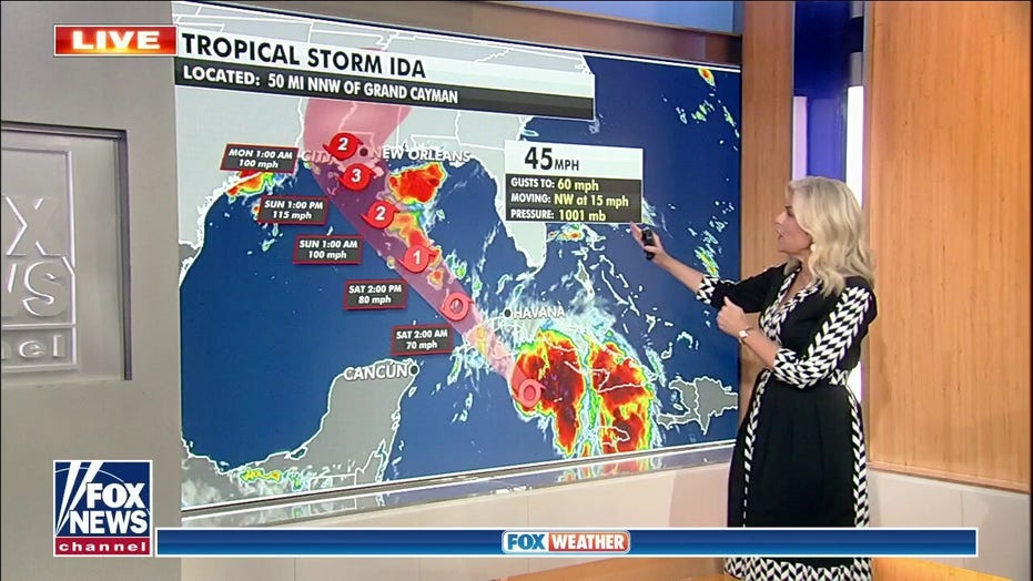
National weather forecast for August 27
Janice Dean has your FoxCast.
Mandatory evacuations are being ordered in Louisiana on Friday as Hurricane Ida barrels toward the U.S. Gulf Coast.
In a Facebook post, the Plaquemines Parish Government urged all citizens to begin personal preparations warning that the mandatory evacuation would take effect at 3 p.m. ET for its entire East Bank and the West Bank from Phillips 66 Alliance Refinery to Venice.
“In addition, a Voluntary Evacuation from the community of Oakville to Phillips 66 Alliance Refinery,” the government said.
As the storm swirled near the Isle of Youth, Cuba, it was forecast to intensify further over the next couple of days.
The National Hurricane Center said Ida – which is pointed directly at New Orleans – will reach 120 mph before making landfall in the Mississippi River delta late Sunday.
Projected to become a Category 3 hurricane, the storm would strike 16 years to the day since Hurricane Katrina made landfall as a Category 3 storm with 125 mph winds near the riverside community of Buras in Plaquemines Parish.
Louisiana Gov. John Bel Edwards declared a state of emergency on Thursday, warning residents to make preparations.
Long lines crisscrossing at a Race Track gas station on Jefferson Highway in Jefferson, La., as people prepare for the arrival of Hurricane Ida on Friday, Aug. 27, 2021. Forecasters now say Ida could be a major Category 3 hurricane with top winds of 115 mph when it nears the U.S. coast.
(Chris Granger/The Times-Picayune/The New Orleans Advocate via AP)
“This type of threat contains additional problems because the window to prepare is so short,” he said, adding that residents should be where they “intend to ride out the storm” by Saturday night.
The Emergency Operations Center at the Governor’s Office of Homeland Security and Emergency Preparedness (GOHSEP) is monitoring the storm and coordinating with FEMA and local parish emergency preparedness offices, the release said.
“Right now we know conditions are primed for this system to strengthen,” GOHSEP Director Jim Waskom said in a statement. “We also know the reality of this impact all too well. That means we all must remain aware of the potential of this severe weather threat, finalize your emergency plans and be ready to adjust those plans due any changes in the forecast or due to potential weather alerts being issued.”
People were seen lining up for groceries and filling sandbags in New Orleans on Friday and some schools in the area closed or moved to virtual classes.
A voluntary evacuation order was issued for Lafourche Parish and there was a recommended order for Port Fourchon, according to Houma Today.
The mayor of the Gulf town of Grand Isle said its Thursday voluntary evacuation order would become mandatory on Friday.
The National Hurricane Center said the hurricane’s maximum sustained winds are estimated to be 75 mph with higher gusts.
Corey Williams, right, and John Smith, both of Pelican Ice, hurriedly stack bags of ice into a gas station freezer in preparation for Tropical Storm Ida on Friday, Aug. 27, 2021 in Jefferson, La. Forecasters now say Ida could be a major Category 3 hurricane with top winds of 115 mph when it nears the U.S. coast.
(Chris Granger/The Times-Picayune/The New Orleans Advocate via AP)
Ida is projected shift near western Cuba later Friday before moving over the southeastern and central Gulf of Mexico this weekend and approaching the northern Gulf Coast.
Ida is also projected to produce a total rainfall accumulation of 8 to 16 inches, with 20 inches in isolated areas from southeast Louisiana to coastal Mississippi and Alabama through Monday morning.
Rainfall totals of 4 to 8 inches are possible later Monday across southern and central Mississippi – with the potential for considerable flash, urban, small stream and riverine flooding – as Ida turns northeast and moves inland.
Fox News’ Brie Stimson and The Associated Press contributed to this report.
Source: Read Full Article


