UK weather: Brits warned to take IMMEDIATE action as 'severe' snow blast hits
BRITS are being warned to take IMMEDIATE action before chaotic 90mph winds, three inches of snow and huge blizzards rip across the UK.
A rare red alert has been issued for Storm Arwen, which will see severe gales rip through Aberdeen down to Newcastle -lasting through to 2am tomorrow morning.


An amber weather warning stretching from the north-east coast of Scotland down to Scarborough warns of huge waves and strong winds until 9am on Saturday.
And another amber wind warning has been issued for tomorrow morning, as the south-west coast of England braces for travel disruption.
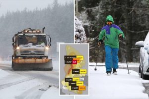
A yellow warning for snow kicks in across swathes of Scotland from 2pm today – with the Met Office claiming "blizzard conditions" and three inches of snow will bring mass travel disruption.
And from tomorrow, up to three inches of snow could fall as far south as London.
During the storm buildings will be destroyed and power lines will topple, and the Met Office have warned that Flying debris poses a "risk to life" under the red warning.
They are urging Brits to get prepared as communities all across the country could become cut off – even in the South.
They warn that people should stock up on foods and medicines, and when indoors, stay warm, heat homes to at least 18°C, and keep up-to-date with the weather forecast.
Meanwhile, Police Scotland has warned that motorists in areas covered by the red warning should not travel "under any circumstances".
Other members of the public are also advised not to travel.
And Brits who live on the coast and are being urged to take special care – as they could be hit with waves as high as 10 metres.
Grahame Madge, a Met Office spokesman, said the forecaster didn't "issue red warnings lightly" and warned people to stay away from the affected area.
He said: "In addition to this one, I would emphasise the risk for coastal communities.
"We are talking about wave heights that really are exceptional. I've heard sort of nine-10 metre waves out to sea, which is you know, is particularly noteworthy.
"We're looking at the vulnerability of people like coastal anglers, for example, shore fishermen, people visiting in order to get photos, all of these communities need to take particular care and assess the risk.
"And obviously, don't go if they feel that there's any risk to themselves or others by them being there."
It comes as low-pressure system Storm Arwen wreaks havoc on the UK – with extremely "strong winds" bringing vast swathes of the north to a standstill.
The UK is being battered by a "little ice age" this week – with temperatures plunging as low as -11C amid "prolonged periods of snowfall" in England and Wales.
The snow kicked off from 2pm today – with the Met Office claiming "blizzard conditions" and three inches of snow will bring mass travel disruption to central Scotland.
Flying debris from the ocean carries a risk of injury and "danger to life", the Met Office warns.
The Met Office said: "An area of rain will move southwards across central, southern and southeast England on Saturday morning.
"Whilst this is expected to be mostly of rain there is a chance that this will turn to snow in places, even to low levels.
"There is a chance of 25cm of snow falling in some locations and perhaps up to 8cm over some of the higher ground above 150-200m.
"Were this to occur some disruption is likely but this would be short lived with any snow melting during the morning.


"The most likely outcome is that most places will see rain with only a little sleet or snow in the heaviest bursts."
Anther yellow warning for wind covers all of Scotland and the west coast of England – with Brits warned of a "danger to life" until midnight tonight.
Gusts are expected to reach 55mph to 65mph in parts of Scotland, Northern Ireland, Wales, south-west England and north-east England, with the highest to be seen in coastal areas.
Stephen Dixon, a Met Office spokesman, said: "The worst-affected areas will predominantly be on the coasts, with gusts of over 75mph bringing possible disruption to travel and longer journey times, power cuts, flying debris and large waves, with beach material being thrown around.
"There is also a yellow warning of wind in place along the west coast of the UK from 9am on Friday, stretching from Scotland, through Northern Ireland and Wales and as far as south-west England.
"This reflects the impact Storm Arwen will have, with strong winds likely to occur into Saturday, when the warning is extended to most parts of the UK.
"The south-east and London, though fairly windy, are likely to escape the worst of the gusts and remain relatively calm in comparison to the rest of the country, which will certainly feel the impact of the storm."
He said Storm Arwen is moving in from the North Sea and will begin to travel south before easing on Sunday.
The Met Office names storms on the back of their potential impact, with Storm Arwen declared as the result of the amber wind warning.
Mr Dixon added: "As Arwen causes disruption there will also be the chance of snow in the coming days, especially in the higher regions of Scotland and northern England.
"There may also be some snow in the lower ground region of northern England, though this is likely to be short-lived and fall in the form of sleet or wintry rain.
"It comes on the back of a fall in temperature, with parts of rural Scotland and England to drop below freezing during the night."
The Met Office has also stressed that red warnings are not issued lightly.
Spokesman Grahame Madge said: "They're only issued when we're advising people to take particular action in terms of weather.
"With this one, in addition to the sort of usual things, you know, structures would be at risk, people need to be aware of things like flying debris, falling trees, that sort of thing.
"In addition to this one, I would emphasise the risk for coastal communities. We are talking about wave heights that really are exceptional. I've heard sort of nine-10 metre waves out to sea, which is particularly noteworthy.
"We're looking at the vulnerability of people like coastal anglers, for example, shore fishermen, people visiting in order to get photos, all of these communities need to take particular care and assess the risk.
"And obviously, don't go if they feel that there's any risk to themselves or others by them being there.
"People need to recognise really, that, you know, we don't issue red warnings lightly, so therefore, when we do we feel that there is a much higher threat of risk.
"We urge people obviously to take action as a result of that and that action in this case is probably don't go to the coast."


We pay for your stories!
Do you have a story for The Sun news desk?
Email us at [email protected] or call 0207 782 4104. You can WhatsApp us on 07423 720 250. We pay for videos too.
Click here to upload yours.
Click here to get The Sun newspaper delivered for FREE for the next six weeks.
Source: Read Full Article